
Recent Comments
Richard & Robyn… on Oz Travel Map 2000 to 201… Lance on Oz Travel Map 2000 to 201… Richard & Robyn… on Oz Travel Map 2000 to 201… Lance on Oz Travel Map 2000 to 201… Richard on Avascular necrosis
On the 22/09/2013 I started my own company, only small working out of Bruce Rock Western Australia.
It is a small Hydraulics Sales & Service company.
Well after (leaving school to early) & starting work at 15 as an apprentice Boilermaker & then migrating to a Fitter/Diesel mechanic/plant fitter/any other thing you can think of. From foreman to supervisor to middle then upper management. at 50 & 1/2 years old, last Wed, it all got to much for me & I pulled the pin on 100000k plus job and I’m going to take a gap year (what ever that means) & sort out the head out , and maybe re-educate myself so I don’t have to do amymore of the SHIT that I have done over the past 34 1/2 years. 🙂
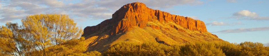
Found this on the way to BK last weekend
Video produced by R2K
This a try out for uploading videos
Video produced by R2K
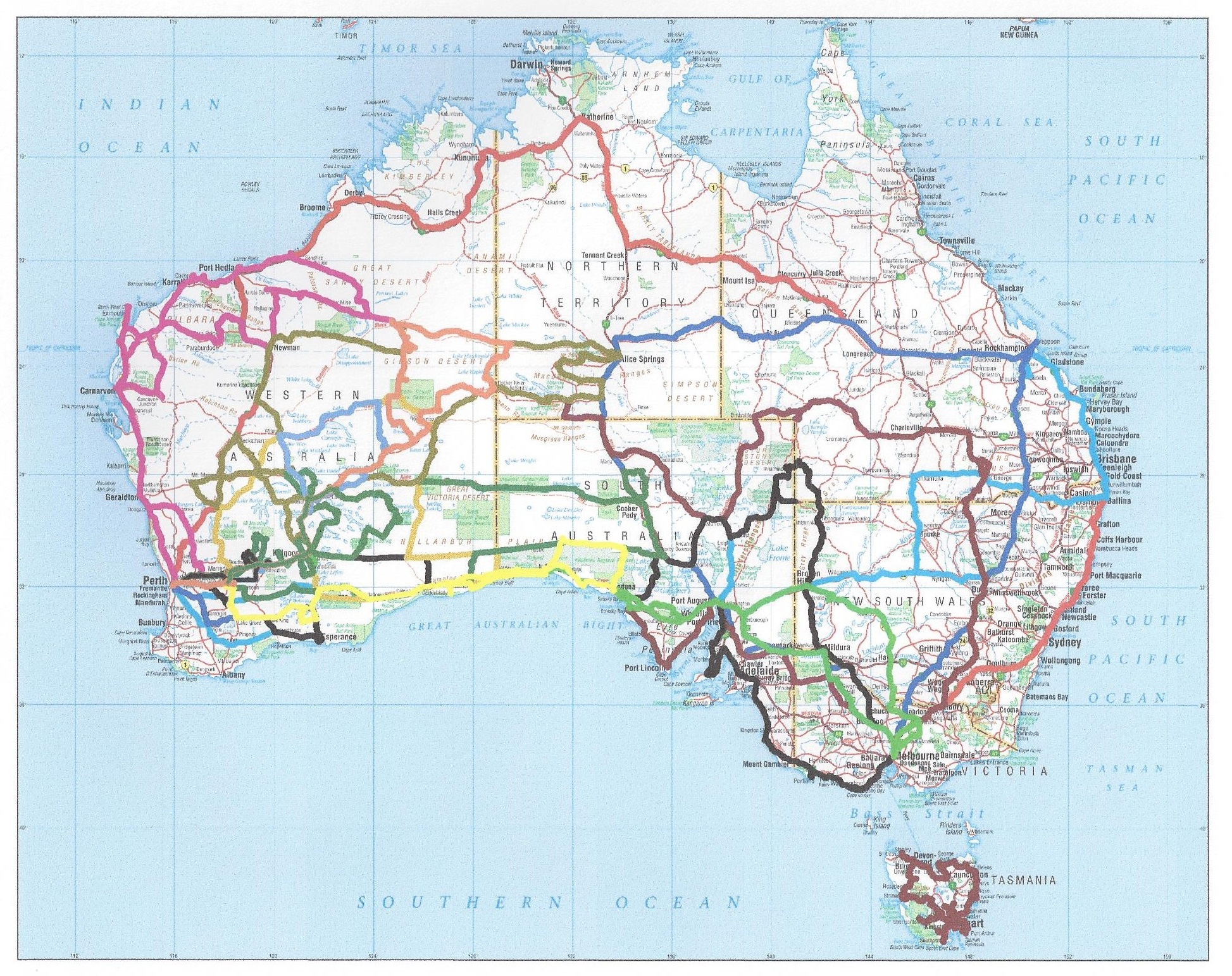
Holiday
11th – 23rd November 2011

We took the trailer after many years without. The trip proved to be free form in planning due to weather conditions (both rain and fire) but it encompassed, Peak Charles, Old Coach Road, Old Eyre Highway, Googs Track, along the Bunda Cliffs, Roe Plain (calling into various beaches and Baxter’s Memorial). It was mix of bush camping and on the way home staying at the Roadhouses along the Nullarbor Plain.

Day 1 – Friday Nov 11th.
We delayed setting out due to rain, again, it was sweeping the interior and Esperance area, so our plans were turned on their head and we thought we’d do the SA sections first and then see what was dry enough when we returned WA side.
Up leisurely, had breakfast and set off from Bruce Rock at 0930. We stopped at Kondinin and enjoyed walking around their mural walk, testing out the video camera (a new acquisition). We then headed down to Lake Grace, had lunch, then across to Lake King. The dirt road deteriorates markedly once you move into Esperance shire, dropping tyre pressures at the old tank by 10psi all around and 6psi on the trailer. On the dirt roads the larger tyres were rubbing occasionally on the body, most likely when it bottoms out.
We got to Peak Charles at 6pm, there was one other vehicle there when we set up camp. The morning was clear but afternoon saw it turn overcast making it impossible to see the moon in the night sky.
Day 2 – Saturday Nov 12th.
Up at 0630, to see sunny, clear skies, Richard made the Meekatharra HF schedule before breaking camp at 0800. We headed out via Anne’s Pass to Peak Eleanora, we went down part way of the road south but it crossed a lot of lake/river country and there was still a lot of surface water on the road. The signs had said no thoroughfare and while the map disputed this we remained cautious and headed down via Dog Rock. We travelled through the nature reserve and when we exited there was a large tree felled line, which we think were fire breaks to protect farming land which we later entered.  We drove through farming country for some time then north onto the highway (replaced the 10 & 6psi) then at Norseman fuelled up and got lunch.
On the bitumen we saw a lot of motor bikes travelling west. Just prior to Balladonia, we saw a dingo and then headed into Newman Rock,  then after Balladonia visited Afghan Rock.
  We made camp at a 24 hour camp site ~70km west of Caiguna, there were heaps of little birds that came up to us to see if there were crumbs. It was a lovely spot and well set up.
  The night was clear (despite it becoming overcast again in the afternoon) and we saw 3 falling stars.
Day 3 – Sunday Nov 13th.
We stayed on WA time for convenience and did not move the 45min forward. We were up at 0630 to again clear skies, and headed off at 0730. The other side of Caiguna, we called into a parking bay, looking for a road which lead off to Rockhole and ran into a friend from Broadford and his son. Had a lovely time catching up with them and swapping news (except the march flies were being a nuisance). Still the bikes came westward and we continued onto Madura (1130), fuelling up and then heading off along the Old Coach Road,  again dropping tyre pressures 10 & 6 psi.
At 3pm we stopped at a blowhole, it didn’t disappoint, the air coming out was like an air conditioner blowing on you. Given the afternoon was very warm it was a pleasant surprise and there was a good campsite on a nearby hill. The road was changeable between clay, rocky, speak grass plains and low overhanging trees. There was a multitude of wildlife, especially kangaroo’s but also cattle, horses, emu’s and birds of all descriptions (flocks of budgies, finches, quails, falcons, hawks, crows, etc.).
Our friends had said they had passed a lot of fires so we made sure that we camped in a clay pan large enough to fit the Troopy and trailer in without touching any of the surrounding grass land.  We camped east of the Forrest – Mundrabilla road, and found we had some wire wrapped around sections of the Troopy and it had to be cut out, cleaned out the spear grass while Richard was there.
Day 4 – Monday Nov 14th.
We awoke to the sound of budgies eating the splattered bugs off the Troopy and getting the condensation being caught in the gutters, it was 0600 (WA time). The sky was blue, a cool breeze was blowing and budgies were fearless. They landed on Richards back when he leant over to pick up something and once we took off they sat on the bonnet until they nearly blew off. We also had to give way to cattle that were using the road before we could head off east again. A small way up the road we saw a mob of brumbies, fresh from rolling in a mud hole,
  who came to check us out, if somewhat cautiously. There were wombat holes everywhere, some clearly abandoned (rabbits having taken up rent) and many with fresh diggings. They seem to like digging at the roadside, with the road edges disappearing underground.
At 0820 we visited Wileura Rockhole  where a family of emu’s watched us from nearby, then onto Tookana Rockhole then Cowillia doline
 . Quails, like yesterday, were running ahead of the Troopy to disappear sideways into the spear grass. Occasionally a peregrine falcon would fly out with something in its claws/beaks, and even dropping it onto the windscreen.
We then did a trip down and back to a series of caves and dolines (collapsed cave). The one at the turn off was Abrakurrie Cave where again flocks of budgies swarmed out of the caves at the bottom of the doline. When we returned to the vehicle, every section of the roof rack was covered with green budgies.  Then down to Kutowalla doline and finally Winbirra cave. The track varied between again grass to a tree crowded path. Many of the bushes were full of bloom and very attractive.
When we turned back onto the Old Coach Road we could see smoke plumes ahead.  We hoped they were north and we were not heading into them. We eventually ran into them. Actively burning north of the roadside ~10m away and much of the country already black and smouldering. There were tyre tracks through sections of the burnt country,
  it turned out to be the Eucla police who we passed coming to check on the fires. After leaving the station country we saw a sign (facing East) stating to call the homesteads prior to entering (Mundrabilla Station 9030 3280 and Madura Station 9030 3447), a bit late for us, we then ran into the police.
We joined the Old Eyre hwy and saw lots of caves/Rockhole’s including Warbla Cave and then headed up to Koonalda Cave. However the fire was burning along the roadside and we thought it prudent to camp at Koonalda and visit the cave the next day.
We camped at Koonalda Homestead near a new building that had a long drop toilet and cleared area around it.  Given the day was still early (4pm) we explored the area, shearing shed, old vehicle graveyard and homestead. As dusk fell it was quite eerie with the golden glow from fires all around us. We prepared for fire-fighting overnight (water sprayers, shovels, etc.) should the fire come that close. We also had some fun trying to get a mouse out of the Troopy, it’d decided it looked like a good place to live. We got there eventually and could finally get to sleep, with one eye on the fires.
Day 5 – Tuesday Nov 15th.
Still on WA time we woke at 0630, the fires had stayed at bay, and set off at 0715. We went up to Koonalda Cave driving through a blackened landscape with stumps still smouldering and smoke still on the horizon.  The day was intermittently cloudy but windy so not too hot. Koonalda Cave was again a huge hole with a cave at the base. The entrance to the cave had been fenced off and where cave explorers would climb into the depths was steel meshed off and padlocked. A huge fig tree was growing in the base.
We travelled onto Nullarbor and did a tourist loop of some open caves, bores, wells and ruins in the area. The caves are linked and again very impressive but not as large as others. At Horse Well it looked like it was surrounded by netting but it was finches sitting on every available wire and surface.
At Nullarbor we fuelled up and bought lunch (a hamburger so large you nearly had to stand on it so you could get it in your mouth), then continued up the Old Eyre Highway, RFDS plane was leaving as we were. The road was limestone and in sections very rough but still wide and the land remained open. About 40km up the road the trailer was all in the passenger side window, it had broken a front spring hanger mount. Richard did his first bush welding and after a bit of trial and error determined you need to two batteries, one is just not good enough. Lots of spark but no weld. The wind was nearly gale force on this open siting and we were worried it might start a fire, Robyn held up a canvas sheet to “collect” the spark, and happily no fires started.
We had no phone reception where we had stopped so could not ring ahead to Fowlers Bay to say we were late until nearly 5pm. We continued on carefully to complete the Old Eyre Highway, eventually finding our way back onto the Eyre Highway and airing up the tyres again. We arrived at Fowlers Bay after dark and made camp before walking around the town and going out on the Jetty.
Day 6 – Wednesday Nov 16th.
Remaining on WA time proved a bit tricky today but we managed. Up at 0650 we again walked out on the jetty and had a look around, we left at 0830, they were upgrading the road out and there was a large snake on the road, dead. On the highway we saw a “storm trooper” pushing a cart heading east also. The radio came alive with trucks discussing if they’d seem what they thought they saw, when we were not hearing harvesting chatter of the farming community who were busy getting in crops.  We got to Ceduna at 1045 and looked around for a steel fabrication shop that could ensure the trailer would last til out the trip. We drove out to the cape but then found the industrial estate on the outskirts and left the trailer with them, to pick up later. We drove along the esplanade and visited a space age toilet (the storm trooper would have fitted right in) with voice and movement activated doors, flushing, taps etc. All stainless steel, full length mirrors and speaking to you it certainly was an experience. Then did shopping for necessities (permit for Goog’s track, tools, I-phone charger, etc.),
  then booked into a cabin as thought we’d stay the night before picking up the trailer. At the cabin, topped up water supplies (with permission), washed clothes and generally relaxed in the air conditioning as a very hot day.
Day 7 – Thursday Nov 17th.
Up at 0500 WA time and left cabin at 0600, visit the fabrication shop as Richard not totally happy with the weld, fuelled up, then on our way. Another hot day with patchy cloud we headed back west briefly til we headed north to the Goog’s track. Airing down again (this time by 20 & 16psi), put the flag on the front and let ourselves through the vermin proof fence.
  We needed to drop tyre pressures again by a further12 & 4 psi to manage the sand dunes. Having not done a lot of previous sand driving it was a experience to see how low the tyres need to be, having the trailer of course was an added trial but only needed to back down a couple of dunes and tried out the max tracks with success, when not quite able to get over the summit.
We visited Goog’s lake and the memorials,  a Rockhole and at Mt Finke put some air into the tyres as the track had become rocky and we foolishly thought the worst of the sand was over. Needless to say we were mistaken and thus had to air down again….
We camped near Trans Australian Railway Line in a reasonable campsite, but still hot i.e. 320C at 6pm (this was 8.30pm local time) so got down the tent as the mozzies had moved in also, and had a half decent sleep eventually, serenaded by the dingos. Had bought a cooling mat (for just this type of occasion) and tried it out and it made a difference.
Day 8 – Friday Nov 18th.
Up at 0500 (WA time), broke camp at 0540 and at 0600 completed the Goog’s track, aired up to normal dirt road tyre pressures.  Today was overcast and stormy, and cooler than the previous day but still very warm. We visited the Wynbring Rocks dam (scaring a family of emus, and sending a deafening array of bird life into the sky). A lot of water collected and worth a look.
 We passed a freight train and not much further on we saw again plumes of smoke in the tree line and later the ravages of fire on the landscape. It appeared to have started near the railway line, we presumed it was sparks from the train breaks.
At Ooldea we headed north to Maralinga,  hoping to see the gates, but they must be further on Maralinga land and as we had no permit we found a spot and turned around. Again seeing a blowhole with air-conditioning like cool air blowing out of it, it had been reo meshed off to prevent stray people/animals losing a let into it.
 Then down the bitumen road, lined with telegraph poles to Watson. Then down to Nullarbor, via Disappointment Cave, nearly lost the Troopy down a wombat hole that was smack dap in the middle of the road.
  Someone had tried to mark it but Richard tried to block the path for future travellers. On the trip back to Nullarbor we saw dingos, camels, and again much bird life.
We stayed at the Nullarbor Motel and started our “pub crawl” back to WA, eating in the bar and soaking up the local atmosphere.
Day 9 – Saturday Nov 19th.
Up at 0530, we discovered the auxiliary battery was flat, the trailer fridge had been left on overnight, bought fuel and food and headed south. GPS satellites being elusive and we took some time to get, but finally all working. Again wombat holes and dingo’s featuring we headed down along the Yalata Regional Reserve fence line to the Bunda Cliffs,  followed the coastline and came out some 50km later on the Eyre highway. We were back in cave country and again visited a couple of them. We dropped into a tourist lookout and there was a car stranded. Many vehicle there but apparently no-one able to help, Richard managed to get the vehicle working and the travellers (women from Israel and Holland and Ozzie male) were able to set off east.
At Border Village we found the road to Wilsons Bluff and had thought we head to Eucla along these tracks but all seemed to disappear into sand dunes. We did find the border cairn (the right one, there are many cairns)  before heading back to Border Village and up the highway to Eucla. We booked into the Motel and then visited the telegraph station and walked out to the jetty (not an easy walk but worth it). Birds took off in all directions when we appeared over the dune, there was also the brow of an old boat buried in the sand and 4 fishing boats up the coast a little way.
  When we got back we visited the museum and the lovely garden behind the roadhouse restaurant, before having tea in the bar, as the fisherman came in to eat also.
Day 10 – Sunday Nov 20th.
Awaking at 0700 we left Eucla at 0800 to a much cooler day. From Eucla we headed along the Roe Plain, through what was the old Eucla town site (nothing to see), into 12 mile and Wanteen beaches  (beautiful with powdery white sand) and onto Noonera ruins. We saw starling traps along the way, some having caught one in them. At the ruins we headed north to join the highway at Mundrabilla Homestead. The track was slow as it’s heavily wooded and very different from the open grass land of the plain. At Madura we checked into the Motel but as the room wasn’t cleaned as yet, we headed for the coast. But some 50km later we were close but not able to get to the beach and having difficulty turning around and very sandy. We gave up and headed back, again a large snake crossing the road (alive this time) and we called into Madura Cave on the
 return trip.
At the motel Richard did some maintenance to the trailer wheel bearings, and generally had a bit of a clean up, we then headed to the bar for tea.
Day 11 – Monday Nov 21st.
Up at 0630 and left at 0715, we followed the road under the scarp (Hampton Range), past more ruins, budgies flocking around the tank, through pretty country.  Tree’s in bloom and open land with the scarp parallel and ran into an oncoming vehicle who were scoping out a 2012 rally for 2 wheel drives from Mandurah – Bendigo. We later passed another vehicle, they were staying at Eyre Bird Observatory and were going in search of the budgies.
  Again visited ruins, before following the telegraph line, going up the scarp and unhitching the trailer and heading back down after radioing ahead. Taking air out of the tyres, we looked for the man who was trimming the roadside (due to high growth from all the rain) and going to the observatory buildings. We paid our entrance fee and were given a tour and the oral history of the area. We also had morning tea with the couple who were helping out. Some Mitchell Cockatoo’s were in the tree nearby and we were informed about the various other birds in the vicinity. Again saw a starling trap and had it explained how they work (starlings in the trap, others come to visit and can’t get back out), if you see one trapped you call DOLA and they’ll collect them.
  Drove down along the beach a short way, then back out to the scarp and picked up the trailer. Setting off we visited the lookout and then up a back road to Rockhole’s, etc. to Tommy Graham’s Cave, Pannikin Plain Cave (this cave travels under the highway apparently), and Murra-El-Elewyn Cave.
  We stayed the night at Cocklebiddy Motel were we again met up with the motor bike riders, heading east this time.
Day 12 – Tuesday Nov 22nd.
Up at 0720 we fuelled up, aired up and set off at 0830. Visited Cocklebiddy Cave, then onto Caiguna, the budgies had come south looking for water and they’d be crushed all over the road where trucks and traffic were hitting them. The Observatory couple said this happened ~25years ago when there was a good season of rain the once the water dried up inland they’d come south, eventually dying on the beach.
We took the road south to Baxter’s memorial. What a slow trip that was, very rocky with limestone and a slate/shale type of rock, overgrown roadside. We visited Baxter’s Memorial and down to Baxter’s Cliffs, and on the return found the Rockhole and sink. Again flowers everywhere, with fields of wildflowers in some sections.
And still the bikes came, returning from a “Hogs Rally”, held annual and this year was in Mandurah. Stayed the night at Caiguna Motel and ate in the bar.
Day 13 – Wednesday Nov 23rd.
Up at 0800 we aired up for last time and headed off at 0830. Called into Balladonia and checked out the museum then onto Norseman and then along the Norseman-Hyden road. We turned north and called into Lake Cronin  and then the air plane crash site
  on the King Ingram Road before heading west to Bruce Rock and end of the journey.
Menu
Words by Robyn Kovac
Photos by Richard Kovac
R2K
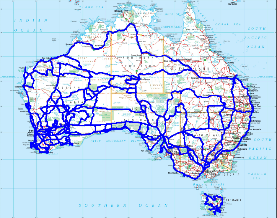
| Richard & Robyn… on Oz Travel Map 2000 to 201… | |
| Lance on Oz Travel Map 2000 to 201… | |
| Richard & Robyn… on Oz Travel Map 2000 to 201… | |
| Lance on Oz Travel Map 2000 to 201… | |
| Richard on Avascular necrosis |
