Trip Report 2009 Days 8 – 14Saturday, Jan 09, 2010 at 23:50
Richard Kovac |
|
|
Holiday
25th May – 7th June 2009 5385.7 km Avg 7.15 Km/L Cheapest Fuel $1.199/L @ Kewdale, Dearest $3.20/L @ Kunnawarritj Avg. $1.7258/L No damage to the Troopy No flat tyres No problems at all this was our first trip was without our dog Benny who’d died a month or so earlier. It was to cover the Hunt Oil Road, the Gary Highway, Gary Junction Road, Sandy Blight Junction Road and abandoned section of the Gunbarrel Highway. Total water taken was 105litres and used a total of 65litres. 
Trip 2009
Day 8 – Monday June 1st
Whau Whau Well
We got the WAPET road, Gary Hwy junction at 1012 and turned up the WAPET road to Kunnawarrtji. Robyn had forgot that it was a public holiday Monday and we were unsure if we’d be able to get fuel or if we’d have to camp the night at Well 33 (again). We had an escort of camels for a couple of kms until they finally vacated the road to allow us a bit more speed. Not long after we saw Kidson Airfield (1040),
Kidson Field
we were back in dune country and large area’s had been burnt out, camels were more plentiful and we saw an abandoned vehicle in the middle of the road.
Looks like a Queenslanders Truck 🙂 We called into the solar bore/tank and put two gerry cans of diesel in the Troopy, odometer reading 1003.3km with both tanks just above empty and took off the spinifex shield.
Windmill and tank (solar Bore)
We got into Kunnawarrtji at 1240, and while we had to wait for the managers to finish lunch we were fuelled up and gone by 1330. In the interim we were speaking with “John” from Pt. Hedland TAFE who was teaching in the communities about back hoes and attachment maintenance etc. While we waited an Ocker joined the queue for fuel.
Kunawarritji
There had been recent rains (within the last few days) and there was water lying in the roadside drains and low lying areas. The Gary Junction Road (Jenkins Track) was in good condition with a couple of rutted areas and occasional corrugations, but easily 60-80km/hr. Just up the road when it back evident that road speeds were higher Richard increase tyre pressure by 5psi so the front had 32.5psi and rear had 50psi.
Gary Junction We were back at the Gary Hwy and stopped to mark the occasion then continued on. We were struggling to find a camp when Richard saw a drum out of the corner of his eye and turned in.
The blue drum
This proved to have large “rooms” that many could have camped in. A very pebbly base but otherwise tree lined rooms opened up into another similar space.
Camp 8
We picked one and made camp (back in the L shape). We topped up the blue water bottle again tonight. We thought we could hear/see bats flying around in the early evening. It was dusk at 1730 and Richard made the schedule at 1800. Day 9 – Tuesday June 2nd
Gary Junction Road
The desert oaks warning you of arrival to the region of Jupiter Well,
Desert oaks
then you just look for the bore, using bore water we refilled the yellow container.
Jupiter Well
We also saw the original well site which was across the road and had fairly new plaques depicting it.
Jupiter Well plaque
We got to Kirrirrkurra at 1140, had planned to fuel up but nothing was open. We met Peter and Heather from SA travellers having lunch while the store was closed for a 1-2hr period. We swapped call signs and road conditions and we left them to their lunch. We found the old burnt out truck that was once Len Beadell near the water tank, there was also an interesting aboriginal monument.
Water Dreaming
We put our clocks on 45mins.
Not used to having a fire we enjoyed it during dusk (1500 WA time or 1850 NT time) and a temperature of 220C, which dropped to 140 within 90mins. We were confused about what time we should be using and decided to remain on WA time. Day 10 – Wednesday June 3rd
Tropic of Capricorn
we then took a road that lead off to rockholes. It had a water resources post near it and evidence of camels drinking from it.
Rockhole
All day was game of hide and seek finding all the blaze tree’s and plaques littered along the way. We had Mt Leisler in the rear view mirror for many miles as it slowly got smaller. At 1100 we crossed the NT/WA border again. We moved into more dune country and many of the dune bypasses had short cuts over the dunes. We took the long way around including one that it seems was blocked off and became a washout that was nearly a river bed. Realising too late to turn around we preserved and was glad to re-join the road some time later. At 1400 we got to Sir Fredrick Range turnoff.
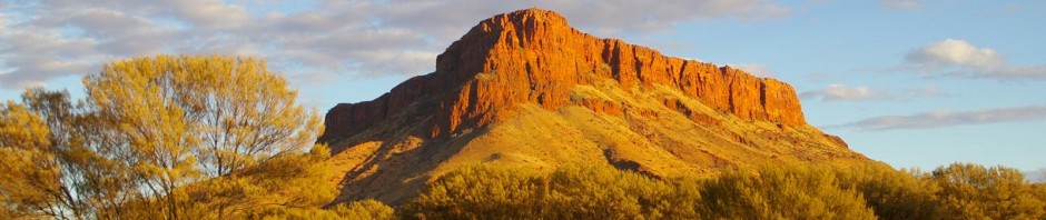
Sir Fredrick Range Turn off
There were two vehicles coming down as we headed up. They had got to the 1.6m point, choosing not to do the last 0.3m as it was very rutted and covered in smooth stones that the tyres didn’t seem to grip that well.
Sir Fredrick Range
We did the same, the view was amazing.
Camp 10
We topped up the blue 5L water bottle again and Richard made the sched at 1830. Day 11 – Thursday June 4th
Bungabiddy Rockhole
The Rockhole was spectacular, you could swim across the water hole and climb a rope to keep exploring, needless to say we stayed dry. Saw plaque on a tree of locals resting place, what a beautiful spot to put someone’s ashes.
Bungabiddy Rockhole
We found more plaques and blaze trees before pulling into Giles at 1130 and fuelling up. A young couple were working 3 of their 12 month stint at the roadhouse (he was from NSW while she was from Adelaide). Then out to the meteorology station. We revisited the old grader that the Gunbarrel construction team used and the Blue streak rocket space junk then a guy said there was a show and tell inside one of the rooms. Worth a look, it included weather and history information, originals of Len Beadells
Giles Met Station
including the painting from the mess hall wall and information on Giles (the explorer) with a photo of his grave stone at Coolgardie. Then onto the abandoned section of the Gunbarrel Hwy, where we saw more blaze trees and plaques, changing landscape and road conditions. Again a few puddles on the road and odd shower nearby. We made camp at 1625 in the same fashion as the previous night and had a couple of light showers of rain in the early evening. Richard made the sched and that night we heard the noise of camels nearby.
Camp 11
We tried to see them with the night vision glasses but while Richard could see them Robyn couldn’t. Day 12 – Friday June 5th
Mippiltjarra Rockhole
We got to Jackie Junction at 1112 and stayed with the Gunbarrel Hwy. We found bullet cases at the junction where people had taken pot shots at the signs.
Old Gunbarrel Hwy
Even the Heather Hwy had some serious washouts. At 1545 we got to the Heather Hwy/Tjirrkarli Road junction and raised the tyre pressure by 5psi again. We set off to find a camp which didn’t materialise and we pulled into Tjukayirla Roadhouse at 2000.
Tjukayirla RH
We had tried to call ahead but couldn’t get through, and after failed attempts of trying to get their attention (we could hear them around the back with friends) we were starting to make camp outside when they heard us and let us into the caravan park for $10/night. We filled the blue water bottle again, and apart from avoiding an emu who seemed at home there, it was wonderful to have a shower and wash our hair…. Day 13 – Saturday June 6th
Old mine and Hall of Fame
Visited the super pit and took a drive around town before checking into a motel $136/night. Richard logged into the computer for the first time in a week and caught up on all his emails. Another shower, “Cantina” pizza, watching the “Wrestler” – who could ask for more… Day 14 – Sunday June 7th
Underground tour
Did the underground tour (tested out Richards hip) which was good and saw the sights, then into the Hall of Fame.
Chinese Gardens
Robyn liked the gardens and we got lunch before leaving to see a blast at the Super pit along with many others.
Super pit Blast, I used to work down there on the 80’s
Then a quick trip to the Museum and out of town via a lake reserve, where quad bikes and trail bikes were all the go, it included an old quarry dam.
Ernest Giles grave
Then home to Bruce Rock, but didn’t quite make it in time for the sched so pulled over in a parking bay just out of town to call in. could only get through via relay from 333 (who’d relayed for many during the whole 2 weeks). We got home at 1830. This has been the best trip we have had so fare, you learn so much as you travel, that it makes you have to do it all again…. Words by Robyn and Richard R2K All Photos can be seen @ https://profile.live.com/cid-e092a94edb141da4/#!https://skydrive.live.com/?cid=e092a94edb141da4&sc=photos |
|


Recent Comments
Richard & Robyn… on Oz Travel Map 2000 to 201… Lance on Oz Travel Map 2000 to 201… Richard & Robyn… on Oz Travel Map 2000 to 201… Lance on Oz Travel Map 2000 to 201… Richard on Avascular necrosis
